
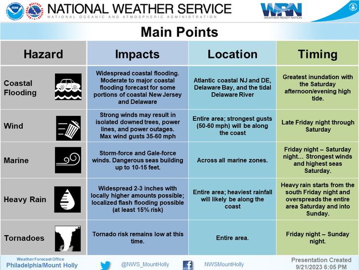
According to the National Hurricane Center and the National Weather Service, heavy rain will move into southeast Pennsylvania Friday night. Widespread flooding, damaging wind gusts, and the chance of an isolated tornado are also forecast as Tropical Storm Ophelia has formed in the Atlantic.
Between two and three inches of rain are expected for the Philadelphia region. Rain showers will continue into Sunday.
“People in coastal areas should take this storm seriously,” AccuWeather Chief On-Air Meteorologist Bernie Rayno said. “This is going to be a nasty and formidable storm.”

The US National Weather Service posted the following safety advice for the Philadelphia region:
1. First and foremost, be sure to stay tuned to the latest forecast and have ways to receive weather watches and warnings. Follow weather.gov/phi , weather radio, TV and radio stations, and/or your favorite trusted source for weather information throughout the weekend. This is true for everyone, but especially if you have any travel or outdoor plans this weekend!
2. Especially for those within the wind advisory or high wind warning area, take the opportunity today to secure any loose objects outdoors before the winds increase early Saturday morning! This includes trampolines, patio furniture, and trash/recycle cans.
3. If traveling within the area covered by the wind advisory or high wind warning area, use caution when driving, especially if you are driving a high profile vehicle on a northwest to southeast oriented road (winds will be coming from the northeast during the strongest of the wind speeds)
4. For those of you in areas prone to tidal and coastal flooding, move objects and vehicles out of low lying areas prone to tidal/coastal flooding. Clear out these low lying areas today ahead of the impactful high tides especially late Saturday.
5. Stay out of the dangerous surf! Whether going to the beach or wanting to go out on a boat, the surf and wave action will be very rough over the next few days. This will lead to a high risk for rip currents, potential for beach erosion, and potential to capsize or damage vessels.
For all the latest news, follow us on Facebook or sign up for Glenside Local’s “Daily Buzz” newsletter here.