
The National Weather Service’s latest forecast describes this weekend’s storm as a mix of rain and snow.
The storm is still expected to arrive early Saturday afternoon and continue through the evening. Rain is possible Sunday morning. From their Event Summary:
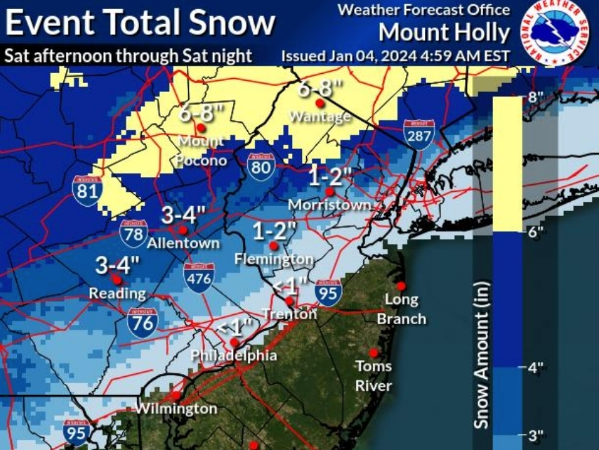
- Snow across the southern Poconos and northwest New Jersey with totals around 4 to 7 inches possible. Some mixing may occur.
- Snow mixing with sleet or rain northwest of the I-95 corridor through the I-78 corridor. Potential for total snow and sleet accumulations near 1 to 4 inches possible.
- Rain near and southeast of the I-95 corridor with totals of 0.5 to 1 inch possible. The precipitation may begin or end as wet snow along the immediate I-95 urban corridor with little to no snowfall accumulation.

Accuweather’s forecast for Glenside shows “Rather cloudy with periods of snow and rain in the afternoon, accumulating a coating to an inch” for Saturday and “A bit of snow and rain at times in the morning with little or no accumulation; otherwise, cloudy” for Sunday.
The National Weather Service’s weekend forecast:
Saturday
Rain and snow, mainly after 1pm. High near 41. Light southeast wind becoming east 5 to 10 mph in the morning. Chance of precipitation is 90 percent. New snow accumulation of less than a half inch possible.
Saturday night
Rain and snow before 10pm, then rain between 10pm and 1am, then a chance of rain and snow after 1am. Low around 34. Breezy. Chance of precipitation is 100 percent. New precipitation amounts between a half and three quarters of an inch possible.
Sunday
A chance of rain, mixing with snow after 1pm, then gradually ending. Mostly cloudy, with a high near 39. Chance of precipitation is 50 percent.
For all the latest news, follow us on Facebook or sign up for Glenside Local’s “Daily Buzz” newsletter here.